MEDA S1-GB
Delta fiume Po
S1-GB Dynamic pylon
Po river delta

Infrastruttura gestita da:
Infrastructure managed by:
CNR

Il sistema osservativo e' supportato e fornisce dati ai progetti/Infrastrutture di Ricerca
The observing system provides data and belongs to projects/Research Infrastructures:
PNRR ITINERIS
HE MARCO BOLO
H2020 JERICO S3
Biodiversita' + PETRI-MED
eLTER-RI
Sito Delta del Po e Costa Romagnola
DANUBIUS-RI
JERICO-RI


Gruppo di gestione dell'Infrastruttura:
Infrastructure management group:
    Bergami C., Capotondi L, Correggiari A., Focaccia P., Riminucci F., Stanghellini G., Ravaioli M., Toller S.
email: siti.osservativi@bo.ismar.cnr.it

La meda S1-GB costituisce una delle due stazioni di misura gestite da ISMAR lungo la costa emiliano-romagnola, al largo del Delta del Po.
La meda e' collocata in un punto di monitoraggio chiave per lo studio delle interazioni tra l'Alto Adriatico e il fiume Po, in un'area influenzata dagli apporti solidi e liquidi del fiume Po. Il sistema e' dotato di dispositivi di logging e trasmissione NRT, sistemi di alimentazione a tensione continua, stazione meteorologica e strumentazione oceanografica a due livelli di profondita' (tra cui sonde CTD, sensori di ossigeno disciolto, clorofilla, torbidita' e CDOM, ADCP). Ulteriori misure sono raccolte di routine nel sito con campionamenti periodici riguardanti la biologia, la chimica e l’oceanografia.
The S1-GB pylon is one of the two oceanographic infrastructures managed by ISMAR along the Emilia-Romagna coast, off the Po Delta.
The pylon is located at a key monitoring point for studying interactions between the Northern Adriatic and the Po River, in an area influenced by the solid and liquid inputs of the Po River. The system is equipped with NRT logging and transmission devices, continuous voltage power systems, a meteorological station, and oceanographic instrumentation at two depth levels (including CTD probes, dissolved oxygen sensors, chlorophyll, turbidity, and CDOM, ADCP). Further measurements are routinely collected at the site through periodic sampling of biology, chemistry, and oceanography.

(2h) 2024-12-09 17:11:03 UTC

MEDA POSIZIONATA - DATI IN VIA DI VALIDAZIONE

METEO

TEMP PRES Rel-HUM Net-RAD W-SPEED W-GUST TW-DIR Battery
Celsius hPa % w/m2 m/s m/s deg_N volts
00:00
01:00
02:00
03:00
04:00
05:00
06:00
07:00
08:00
09:00
10:00
11:00
12:00
13:00
14:00
15:00
16:00
17:00
18:00
19:00
20:00
21:00
22:00
23:00

ELASTIC BEACON DEPLOYED - DATA UNDER VALIDATION

CTD @ 1.0m

TEMP SAL DOXYG DOPT CHL TURB CDOM
Celsius PSU ml/l ml/l microg/l units ppb
00:00
01:00
02:00
03:00
04:00
05:00
06:00
07:00
08:00
09:00
10:00
11:00
12:00
13:00
14:00
15:00
16:00
17:00
18:00
19:00
20:00
21:00
22:00
23:00

CTD @ 22.0m

TEMP SAL DOXYG
Celsius PSU ml/l
00:00
01:00
02:00
03:00
04:00
05:00
06:00
07:00
08:00
09:00
10:00
11:00
12:00
13:00
14:00
15:00
16:00
17:00
18:00
19:00
20:00
21:00
22:00
23:00

In questa pagina sono presentati i valori giornalieri a risoluzione oraria della Meda oceanografica S1 (dati meteo e CTD), oltre ad informazioni di tipo generale.

This page shows the daily, 1-hour rate meteo and CTD data from the S1 oceanographic beacon and other more general information.

ATTENZIONE: I dati sono ancora in fase di verifica e controllo.

WARNING: Data are under verification and control.

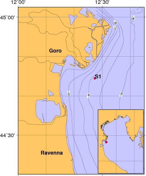
La posizione della meda S1 al 2015-08-04 e' 12 27.1588 E 44 44.3097 N; Profondita' 21.3m s.l.m.

S1 elastic beacon position at 2015-08-04 (18:00 UTC) is 12 27.1588 E 44 44.3097 N ; Depth 21.3m

BUOY_IDOWNER_IDDATE_STARTLATLONWDEPTHDATUM
S1ISMAR-BO2004-04-0544.74104212.45611122.5WGS84

BUOY_IDGEOLOCTYPEMANUFACTURER
S1PO DELTAMETEO/CTDCOMMUNICATION-TECHNOLOGY

Mappa del sito S1 e schema tecnico del sistema Meda- S1 Site map and elastic beacon technical details